🏗️ Open or Closed? What Does a Wall’s Vapor Strategy Change in Building Design?
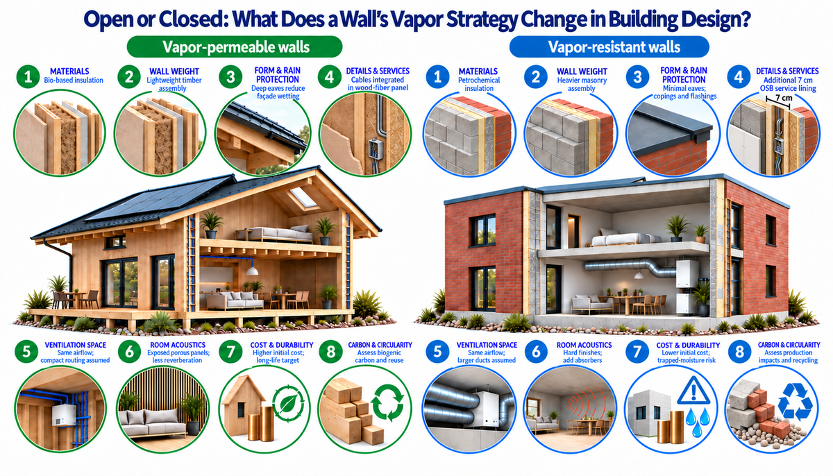
Two buildings. Two wall strategies. Two fundamentally different approaches to moisture management. Which one performs better over time?
When designing a building envelope, one of the most consequential decisions is often invisible: should the wall allow water vapor to diffuse and dry, or should it strongly resist vapor movement?
This distinction between vapor-permeable (diffusion-open) and vapor-resistant (diffusion-closed) construction goes far beyond insulation selection. It influences material compatibility, moisture safety, construction detailing, drying potential, durability, and environmental performance.
The illustration compares two architectural concepts: a lightweight timber building with bio-based insulation and a conventional masonry building with petrochemical insulation.
But the central question is not timber versus masonry.
It is whether we design walls primarily to manage moisture through controlled storage and drying, or to restrict moisture entry through resistant layers.
🌿 1. Vapor-permeable walls: manage moisture and allow drying
Diffusion-open construction recognizes that some moisture may enter the building envelope through vapor diffusion, construction moisture, or occasional wetting.
Instead of relying exclusively on highly resistant vapor barriers, the assembly combines controlled vapor movement, moisture-buffering materials, and drying capacity.
Typical materials include wood fiber, cellulose, hemp, timber, and clay-based finishes.
The approach relies on three principles:
- Control moisture entry: Maintain airtightness, appropriate vapor resistance, and protection against wind-driven rain.
- Buffer moisture: Use hygroscopic materials capable of temporarily storing and releasing moisture.
- Enable drying: Design compatible material layers and drying paths, often toward a ventilated exterior cavity.
The potential advantage is greater tolerance of limited, occasional wetting, provided that the moisture load does not exceed the assembly's drying capacity.
However, vapor permeability is not a guarantee against condensation, mold, or timber decay. Sustained wetting, poor rain protection, and incorrectly arranged layers can still cause serious failures.
The philosophy: limit moisture entry, accommodate small moisture loads, and provide a reliable way for the assembly to dry.
🧱 2. Vapor-resistant walls: restrict moisture movement
Diffusion-closed construction takes a different approach.
Rather than relying primarily on vapor diffusion and moisture buffering, it uses low-permeance materials and carefully controlled interfaces to restrict water vapor entering moisture-sensitive parts of the assembly.
Typical components may include polyethylene membranes, foil-faced PIR/PUR insulation, sealed vapor-control layers, and other materials with high vapor diffusion resistance.
The approach relies on three principles:
- Limit vapor entry: Use sufficiently resistant and continuous vapor-control layers.
- Prevent unintended wetting: Protect the assembly from rain penetration, air leakage, and construction moisture.
- Manage residual moisture: Verify that any moisture entering the assembly can be safely accommodated or removed.
When correctly designed and executed, vapor-resistant walls can deliver excellent thermal performance and long service life.
Their vulnerability arises when water enters an assembly with limited drying paths, particularly where moisture becomes trapped between highly resistant layers.
The philosophy: minimize moisture entry and ensure that any remaining moisture does not accumulate to damaging levels.
💧 3. The real difference: what happens when a wall gets wet?
This is where the comparison becomes particularly important.
Imagine two walls exposed to a small, unintended moisture load.
In a properly designed vapor-permeable assembly, moisture may be redistributed, temporarily stored, and subsequently released through available drying paths.
In a vapor-resistant assembly, the same moisture load may take longer to dissipate if low-permeance layers restrict drying in both directions.
But this is not universal. A vapor-resistant wall with an effective drying path may outperform a poorly detailed diffusion-open wall.
The decisive variable is not simply how much vapor a wall allows through. It is the balance between moisture entering, moisture being stored, and moisture leaving over time.
This requires assessing temperature, relative humidity, vapor diffusion resistance, capillary transport, wind-driven rain, and drying conditions.
🏠 4. Eight architectural and construction implications
The illustration explores how these two moisture strategies can be combined with different architectural and construction choices.
| Design dimension | Vapor-permeable timber concept | Vapor-resistant masonry concept |
|---|---|---|
| 1. Materials | Bio-based, hygroscopic insulation | Petrochemical, low-permeance insulation |
| 2. Wall weight | Lightweight timber assembly | Heavier masonry assembly |
| 3. Rain protection | Deep eaves and ventilated cladding | Copings, flashings, and protected junctions |
| 4. Services | Protected airtight layer with integrated service routes | Sealed control layers with additional service lining |
| 5. Ventilation | Compact distribution concept | Larger ducted distribution concept |
| 6. Acoustics | Exposed porous finishes | Hard finishes with additional absorbers |
| 7. Durability | Drying potential and moisture buffering | Moisture exclusion and barrier continuity |
| 8. Carbon and circularity | Renewable materials and potential reuse | Fossil-based impacts and recycling considerations |
An important distinction: these are two illustrative building concepts, not eight inevitable consequences of vapor permeability.
A timber building can use vapor-resistant construction. A masonry building can be diffusion-open. Ventilation requirements depend on occupancy and indoor air quality, while acoustics, structural weight, architectural form, and carbon emissions depend on the actual systems and materials selected.
Nevertheless, the comparison demonstrates how a moisture-control philosophy can influence a wider set of design decisions.
🔧 5. Airtightness is essential in both approaches
One of the most persistent misunderstandings is that vapor-permeable walls should allow buildings to breathe.
Vapor permeability is not air permeability.
Water vapor diffusion through a material is different from moisture transported by uncontrolled air leakage.
Air leakage can carry substantial quantities of moisture into an envelope, potentially causing localized condensation.
Both strategies therefore require continuous airtightness, properly sealed junctions, and appropriate ventilation.
A diffusion-open wall is not an excuse for uncontrolled air movement, just as a diffusion-closed wall is not automatically airtight.
🌧️ 6. Durability depends on climate, exposure, and execution
There is no universally superior wall strategy.
A wall suitable for a cold, relatively dry climate may behave differently in a humid maritime climate, a hot-humid environment, or a building with high internal moisture loads.
The appropriate choice depends on:
- Climate and seasonal vapor-pressure gradients.
- Wind-driven rain exposure and façade orientation.
- Existing construction and its drying capacity.
- Material properties, layer sequence, and airtightness.
- Construction quality, maintenance, and expected service life.
For retrofits, the decision is particularly sensitive. Adding internal insulation can cool existing masonry and change its moisture balance, increasing the importance of evaluating interstitial condensation, rain exposure, and freeze-thaw risks.
A technically sound wall must be evaluated as a complete hygrothermal system, not as an isolated insulation product.
♻️ 7. What about embodied carbon and circularity?
Diffusion-open construction is frequently associated with bio-based materials such as timber, hemp, cellulose, and wood fiber.
These materials can offer opportunities for renewable resource use, biogenic carbon storage, and reduced dependence on fossil-based products.
Diffusion-closed construction is often associated with synthetic membranes and petrochemical insulation, although this is not a necessary relationship.
Vapor permeability itself does not determine environmental performance.
A credible comparison requires life-cycle assessment, including production impacts, transport, construction, maintenance, replacement, biogenic carbon accounting, and end-of-life scenarios.
The real opportunity is to combine moisture safety, low embodied carbon, durability, and circularity, rather than optimize one objective at the expense of the others.
🔬 8. From construction philosophy to performance verification
Choosing between diffusion-open and diffusion-closed construction should not be a matter of preference, tradition, or marketing.
It should be supported by building physics.
The equivalent air-layer thickness, sd = μ × d, describes the resistance of individual layers to water vapor diffusion.
But knowing the sd-value of a material is not sufficient to establish the safety of the entire wall.
For moisture-sensitive or complex assemblies, transient hygrothermal simulations, such as those performed with WUFI or comparable validated tools, can help assess seasonal moisture accumulation, drying potential, and sensitivity to climate and material properties.
Laboratory and field measurements remain essential for understanding how real assemblies behave, particularly at junctions and penetrations.
Research by Piggot-Navarrete et al. (2024) on prefabricated lightweight wall systems demonstrates the importance of assessing heat transfer, vapor behavior, and airtightness together. Their findings also highlight the influence of panel junctions and the potential of hemp-fiber insulation in optimized wall assemblies.
📚 Research reference: Hygrothermal and airtightness performance assessment of prefabricated lightweight wall systems for cold climates, Journal of Building Engineering, 98, 111500.
https://doi.org/10.1016/j.jobe.2024.111500
🏗️ The bigger question: should walls resist moisture or manage it?
The conventional debate often presents vapor-permeable and vapor-resistant construction as competing solutions.
Yet both approaches share the same fundamental objective: keeping moisture levels below thresholds that compromise thermal performance, indoor environmental quality, and material durability.
The difference lies in how they achieve this objective and how much drying potential remains when unintended wetting occurs.
A robust building envelope must do more than resist moisture under ideal conditions. It must remain safe under realistic variations in climate, workmanship, construction moisture, and use.
The best wall is not necessarily the most vapor-permeable or the most vapor-resistant. It is the wall whose moisture-control and drying strategy remains reliable throughout its service life, with the lowest feasible environmental impact.
I would be interested to hear from architects, engineers, researchers, and building envelope specialists:
Do you prefer diffusion-open or diffusion-closed wall systems, and what evidence guides your decision?
📚 Explore our research and resources: https://www.shadyattia.org
🏛️ Sustainable Building Design (SBD) Lab: https://www.sbd.uliege.be
💻 Subscribe to my newsletter: https://lnkd.in/diTVT5eq
🅱️ Bilibili: https://b23.tv/bzjL3bn
🎬 YouTube: https://lnkd.in/erHrfkNf
🔗 Professional links, including WeChat 🟩💬 微信: https://lnkd.in/eN3xZhhZ
#BuildingScience #BuildingPhysics #BuildingEnvelope #MoistureManagement #VaporPermeability #HygrothermalPerformance #DiffusionOpen #DiffusionClosed #TimberConstruction #BioBasedMaterials #BuildingDurability #EmbodiedCarbon #CircularConstruction #SustainableArchitecture #ULiege #SBDLab